Losing navigability due to heavy siltation, creating scope for land grabbers
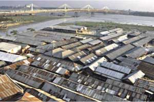 The Karnaphuli river, a lifeline for Chittagong city and the port, is gradually losing navigability with its width already shrunk by 50 to 270 metres at several points in the last two decades.
Its depth reduced sharply for heavy siltation, disposal of huge quantity of waste from the city and lack of planned dredging, says the annual Hydrographic Survey Chart, prepared by the Hydrographic Department of Chittagong Port Authority.
Silt deposits have surfaced in the river while encroachers continue to set up illegal structures on the broadened banks.
Nearly 40 illegal establishments including sugar and oil mills, cement and ice factories, cold storage, shipyards, and warehouses have been set up on its northern bank from Kalurghat to Majhir, and on both sides from Majhirghat to Patenga Jetty-15, according to a survey of the Department of Environment (DoE), Chittagong.
Additional Deputy Commissioner (Revenue) Ismail Hossain said they identified more than 200 illegal structures including 20 large ones on both banks from Kalurghat to the Karnaphuli estuary in Patenga.
The Hydrographic Survey Chart 1989-90 shows the river’s width at Bridgeghat point at 870 metres while the 2009-10 chart puts it at 600 metres. In 1990, its width at the mouth of Chaktai canal was 650 metres that came down to 600 metres last year, the last survey shows.
The river saw heavy siltation over an area of 2.5 square kilometres downstream the northern bank up to Sadarghat. Its depth also decreased by two to three metres at different points, said officials at the CPA Hydrographic Department.
Shahriar Khaled, member secretary of Karnaphuli River and Environment Committee, said the river has shrunk for lack of maintenance and dredging.
M Habib-Ul-Alam, chief hydrographer of the CPA, however, said the river still has the required navigability for movement of port-bound vessels.
Khademul Bashar, director of the Capital Dredging Project, said the situation would improve a lot after completion of the capital dredging that started this month.
Under the project, dredging would be done in two kilometre area of the river from Sadarghat jetty to some 500 metres off the third Karnaphuli Bridge.
He said the capital dredging would restore the river’s depth of four metres for vessel movement through those points where navigability decreased drastically.
The CPA would also remove the illegal structures on river banks as part of the project, he said.
The High Court on August 22, last year directed the director general of the Department of Land Survey and Records, the DG of DoE and the Chittagong deputy commissioner to demarcate the Karnaphuli river’s original area, stop encroachment and demolish all illegal structures on the river in six months.
The court directive came following a writ petition filed by the Human Rights and Peace for Bangladesh, a non-governmental organisation.
Chittagong Deputy Commissioner Foyez Ahmad said they have almost completed the demarcation of the river area. Eviction drives would start after installation of demarcation pillars.
The administration is keeping a close watch so that no new illegal structure is set up on the river, he said.
As the deadline for executing the HC orders had expired, they appealed to the HC for an extension, said ADC Ismail Hossain.
Courtesy of The Daily Star

