Faulty demarcation flouting HC order creates scope for grabbing the river’s foreshore
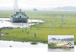 The government itself now seems poised to make the Buriganga a leaner stream by squeezing its shorelines in violation of a High Court order.
Earlier, in April last year, the Turag river suffered a similar fate as Gazipur district administration demarcated it by excluding the foreshores.
Dhaka district administration and Bangladesh Inland Water Transport Authority (BIWTA) started demarcation of the Buriganga and part of the Turag and Balu rivers from Keraniganj in December last as per cadastral survey (CS) records.
They are doing the job on the basis of the revised survey (RS) records that exclude foreshores recovered from illegal occupation a decade ago. They are even ignoring
the legal definition of river foreshore, said competent sources.
The authorities have also disregarded a government committee’s recommendation for a fresh survey to identify the foreshores before starting the demarcation work.
They will set up 6,000 pillars along 99-kilometre long river stretch from Fatullah to Ashulia at a cost of Tk 15 crore.
Pillars have already been set up along the lean water flow of the Buriganga stretching from Sinnirtek towards National Botanical Garden and Birulia. Concrete pillars
have been installed in Ramchandrapur and Ashulia also, virtually turning the river into a canal.
As a result, the breadth of the Buriganga will shrink considerably from what it was before the 2009 verdict of the HC.
The HC in its order had asked administration of the districts concerned to demarcate the Buriganga, Shitalakkhya, Turag, Balu and Dhaleswari rivers with boundary
pillars retaining both the eroded area and formed land (char) as integral parts of the rivers as per CS and RS records.
Foreshore is the land of a river lying between the low water mark and high water mark of normal tide during dry season and monsoon. It is defined by law as an integral
part of the river.
Zanendra Nath Sarker, additional deputy commissioner (revenue) of Dhaka, told The Daily Star that including foreshores as part of the river would entail a large area
of “private land”, as the practical situation is different.
“We are setting up boundary pillars along the flowing water and have informed the court about it, though the court has not yet permitted us to do the job this way,” he
added.
Following a writ petition by Bangladesh Environmental Lawyers Association (Bela) in 1999, a High Court bench had ordered the government to evict those occupying the
Buriganga and recover the public property in the river as per CS records.
Accordingly, BIWTA along with the Dhaka district administration had demolished nearly 3,000 illegal structures to recover the foreshores in Kamrangirchar, Lalbagh,
Keraniganj, Fatullah, Shashanghat, Shyampur and Shyambazar in 2000 and 2001.
Contacted, a BIWTA official involved in that eviction drive said most of the river area reclaimed then has been occupied again by some “private owners.”
It is impossible to evict the occupiers as it would create law and order problems, said Zanendra adding that a big part of the river, as per CS records, has been
transferred to “private owners” in the RS records.
He, however, could not explain how an individual can be a legal owner of eroded and formed land (char), which is khas land.
Syeda Rizwana Hasan, chief executive of Bela, said a district administration cannot demarcate a river by following only the RS records as the HC had ordered to follow
both the CS and RS records. The court also directed them to follow the relevant laws giving highest priority for river, she added.
Official sources said the administration in many districts has leased out most of the river foreshores over several decades in violation of related laws and now they
are unable to bring the rivers back to their original state.
A special committee headed by the state minister for land last year had decided that the authorities would identify the foreshores as per high-water mark during August
and September.
Shaid Ullah, BIWTA deputy director of Dhaka river port, said, “We have not yet conducted any fresh survey to identify the Buriganga foreshores. We are setting up the
boundary pillars on the basis of a map prepared in 2005.”
He claimed that there is no foreshore in Sinnirtek and Birulia as the river runs through plain land there.
But another BIWTA official said in such cases both the CS and RS maps have to be followed to demarcate the river.
Courtesy of The Daily Star

